
Sun and Salt

Kayaks on the Salt Pond inlet, Cape Cod National Seashore
I haven’t been doing much photography the past six months. Too many other distractions. I’d taken this photo back in June, actually before the last one I’d posted, and had planned to post it, but then somehow forgot all about it. Now that the weather’s turning cold, it’s a nice reminder of warmer days.
The location is the Cape Cod National Seashore, on a narrow channel between Salt Pond, on the right, and Salt Pond Bay, on the left. Rather literal names, and somewhat lacking in variation. But they get the point across. It’s actually a couple of miles from here to the ocean, through a maze of twisting channels and low marshlands. To the north, left and behind me, is an area that’s a mix of national park and private land, with a few houses, roads and a trail eventually leading to Coast Guard Beach.
It’s a good area for hiking, and one I recall fondly: when I was about ten (I think; memory dims) my school class spent a week at the old Coast Guard building, walking the trails and studying the animals and plants of the region. It was a very enjoyable time, even if I did think my legs were going to fall off by the end of it.
So I like this image in part for the recent memory of a warm late-Spring day, and in part because it triggers an older nostalgia. But I also like it because I think it captures the sense of place well. A warm day of bright sunlight, with little wind. The tang of salt on the air. Absolute quiet. A very peaceful day. The anonymous kayakers, moving so slowly I could capture them in an HDR set of images, were the only motion at all (there’s some visual noise if you look closely at them).
This image is, as mentioned, an HDR, composed from my usual bracket of five photos. The bracket was centered at 1/320’th-second exposure, with f/10 and ISO 400. My 24-105 lens (the usual) was most of the way out, at 96 mm. I’m fairly sure I had the circular polarizing filter on (hence the fairly high ISO for a bright day). I don’t recall what preset or adjustments I used to make the image, but I think I did very little, the software pretty much got it right on the defaults.
Room With a View

It’s been a while, partly due to lack of inspiration; I’ve taken quite a few photos over the last eight months, but none really spoke to me once I pulled them off the camera and looked. I’ve also been hiking over familiar trails a lot recently, and the lack of novelty was a factor as well.
I was hiking through a conservation area in Brewster, Mass., last weekend when I came across this box on a tree overlooking a pond. I’ve seen similar boxes before, but the run-down appearance, the view over the pond, and the way the leaves bracketed it all drew my eye,
I’d thought at first that it was a bat box, but a little research showed that it was all wrong for that. Rather, it was a birdhouse (a.k.a., nest box), intended to encourage some kind of bird to nest there.
Exactly what kind of bird isn’t clear. Without knowing the size or placement of the entry hole (which I couldn’t see from land) there is a wide range of birds it might have been designed for, from bluebirds to small owls,
Whatever it was, it wouldn’t be in use now, with the bottom rotted open. That’s partly due to the flat roof (bird house roofs should be pitched to shed rain and snow). It also appears to lack drain holes in the floor, which would have shortened its life.
A birdhouse replicates a natural cavity between branches or inside a partially-rotted tree, a favored location for protected nest construction. Birds are particular, so depending on how one is constructed it will likely be suitable for one or a few species. They’re a way to compensate for limited habitat, by increasing the number of birds nesting in an area, and the survival rate of young birds.
I like this photo for the way the box fits into the scene: obviously artificial, yet almost natural. The moss growing on it, and the worn character of the wood enhances that feeling.
This image is, as usual, an HDR assembled from a bracket of five photos taken at one EV offsets. In this case the bracket was centered at 1/200th-second, at f/11 and ISO 1,600. I used my 24-105 zoom, all the way out. A circular polarizing filter was used. In the HDR software, I used the “deep 2” preset, mainly to increase the saturation on the leaves, although it also boosted contrast to bring out the grain of the wood and the tree bark.
Another Look

It’s been a while, mostly because I was busy, but also because I just haven’t been driven to grab the camera this summer.
But today I was back in Lowell, revisiting a recurring subject, the Moody Street Gatehouse on the Merrimack canal in Lowell, Mass. I’ve photographed this before, although from the other side. Actually, I’ve taken a lot of photos of it, but didn’t like most of them. That’s partly because the best side is generally shadowed by the afternoon, which is when I’m usually there.
The gatehouse itself is one of the older parts of the mill complex, dating from 1848 (as you can see spelled out in the bricks if you look closely). It’s really just a cover to keep the rain off the valves that let water from the Western canal into this end of the Merrimack canal, required after additional mills fed from the original Pawtucket canal were using that water. It’s a bit ornate for a rain shield, but by this point the mills were very successful, and had the money to spend on civic beautification. They lined their canals with trees, too, to make them a comfortable place for strolling, a significant recreational and social activity of the day.
The rail line ran in roughly the same place back when it was built, too. Although back then it carried freight trains pulled by steam locomotives, and today it’s a tourist line used by vintage trolley cars from the early 20th century. Today’s was an open-sided excursion car, which I rode back from the far end of the line after walking the length of the tracks.
It was a lovely old car, in richly varnished wood (and some paint), open to the air with running boards on both sides. They probably wouldn’t let you ride on the boards (I didn’t ask), but in this day I’m surprised the let an open car like this carry passengers along busy streets at all. Although the two-person crew did include a flagger, who would walk out into the intersection and wave a red flag before the car crossed. The rather strange-looking traffic light is actually a signal for the trolley, but connected to the intersection’s traffic light so it warns the trolley to stop when cars crossing the rails have a green light.
I like the way this photo captures the late afternoon tranquility of this area. Despite it being in the middle of a busy city (I had to wait several light cycles to get a break in traffic to take this photo) the wooded canal is quite peaceful. And more than a century and a half on it was still home to several groups of strollers, although the ones I saw looked to be tourists rather than townsfolk. And that’s another aspect of the image that I like: the mix of old (gatehouse, trolley wires) and modern (road, trash can, and signal)
This image is, as is typical for me, an HDR composed from a set of five photos at 1 EV offsets. The center was at 1/200-second exposure, with ISO 400 and f/11. Adjustments were minimal: I took the balanced preset, which tries to correct for the typical washed out look of a RAW file without too much distortion of colors, and only made a mild tweak to improve contrast. I used my circular polarizing filter, which helped bring out the cloud detail. The strong yellow cast is from the setting sun, not yet down but getting there, as the lengthening shadows show.
A Fresh Look

It’s late in coming, much like this post, but Spring is finally beginning to show up. The trees are putting out buds, and there are insects in the air. I guess you have to take the good with the bad.
I planned a hike in Northborough’s Edmund Hill Woods for this weekend’s activity, but since trees tend not to be the most photogenic of scenes (hence much of the lack of recent photos) I stopped off at the nearby Wachusett Aqueduct to take a photo. It’s hard to believe that my last one here was four years ago, but it was. As I’ve previously discussed this, I won’t repeat that detail, except to note that it’s been out of service for about fifteen years now, although kept as a backup. The modern aqueduct now runs in a deep tunnel bored through solid rock, rather than a brick-lined channel.
I do like the look of this structure, with its rather pointless cast-iron handrails (it was closed to pedestrians during its operational life, although that’s changing now) and the edge detail along the top, that mirrors the shape of the interior channel where the water flowed. The while color, lime leached out from the flowing water over decades, gives it an interesting look, compared to the usual gray this granite would be.
When I photographed this the sun was ducking in and out from behind clouds, and I thought I’d want a brightly lit image. But this one, taken with the sun behind a cloud, looked better to me when I reviewed them. The shadows under the arches are muted rather than sharp, and there’s a late-afternoon yellowish cast to everything, which I think the cloud enhanced. It works well with the yellowish leaves of the foreground shrub and the buds on the trees, and provides some contrast to the blue sky.
This photo is a single photo, not my usual HDR. It was taken as ISO 400, f/11, with a shutter speed of 1/50th of a second, and with the lens at 47mm. I used my circular polarizing filter, but had it turned down so the effect was mild. Processing only involved a mild crop to remove some foreground dirt and trees on the far right, and the addition of some sharpening.
Relics of a Past Life
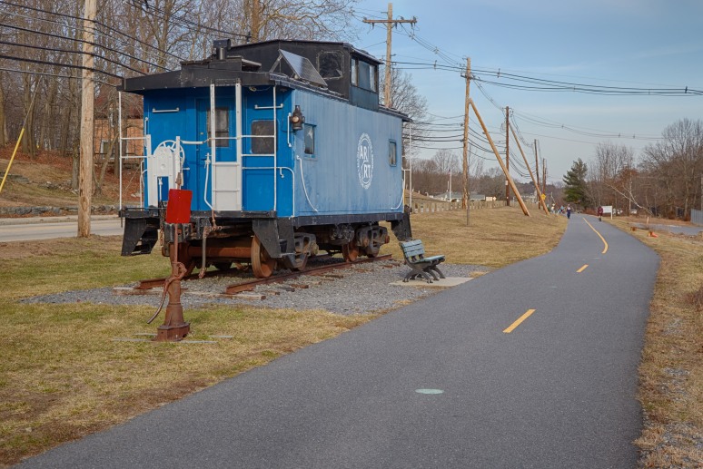
The colors are of the old Boston and Maine Railroad, but the caboose is marked only with the logo of the Assabet River Rail Trail, a discontiguous series of trails crossing five towns along a former railroad right of way. Some sections are paved, others still dirt, and the line is apparently broken by privately owned sections. Two rivers lack bridges. It’s an ambitious undertaking, and one that seems to be making progress, albeit slowly.
I walked a section through Hudson last weekend, from the center of town east to the end of the currently paved portion. It was a lovely day, unseasonably warm, and many others were out for a walk. Along the way, I passed this old caboose, which seems to capture the history of rail trails in a nutshell: once an industrial lifeline to smaller mill towns that lacked water access, now a recreational facility serving the suburban commuter families who have revitalized those old mill towns.
This one is particularly nice, with some public sculpture in the center of town, in addition to this, plus a scattering of benches for less energetic walkers. Although this stretch runs alongside a busy highway, it still felt somewhat isolated from the traffic by the wide margin of grass, and once it ducked away from the road and ran through the woods, you could forget it was even in suburbia.
At one point the old Mass Central right of way crosses overhead. The bridge is long gone, but the steel rails still stick a few feet out into space from the top of the stone abutments. That line, also owned by the B&M by then, was abandoned in 1980 but trains hadn’t run on it in 15 years, and lifting the rails would likely have cost too much so they’ve remained, rusting away in the woods. As, I suspect, the rails were here until work started on the trail in 1997.
This section of the rail trail’s line was also abandoned by the B&M in 1980, but the portion just east of here, beyond the end of the paved trail, was abandoned in 1943, probably one reason stitching it back together has been a slow process.
I like this photo for its juxtaposition of old and new, and for the way the trail curves and vanishes over the crest of a small hill, near where it crosses over the Assabet River, both leading the eye away from the caboose and then throwing it back.
This image is, as usual, an HDR made from a bracket of five exposures. This was centered at 1/160th-second exposure, at ISO 800 with f/11, and with the lens at 55mm. Processing was relatively minor, with a touch of saturation and contrast, and a slight boost to both overall exposure and to blacks. The color seems right for the time, the sun low and providing a somewhat diffuse light with some shadows, but not low enough to have yellowed significantly.
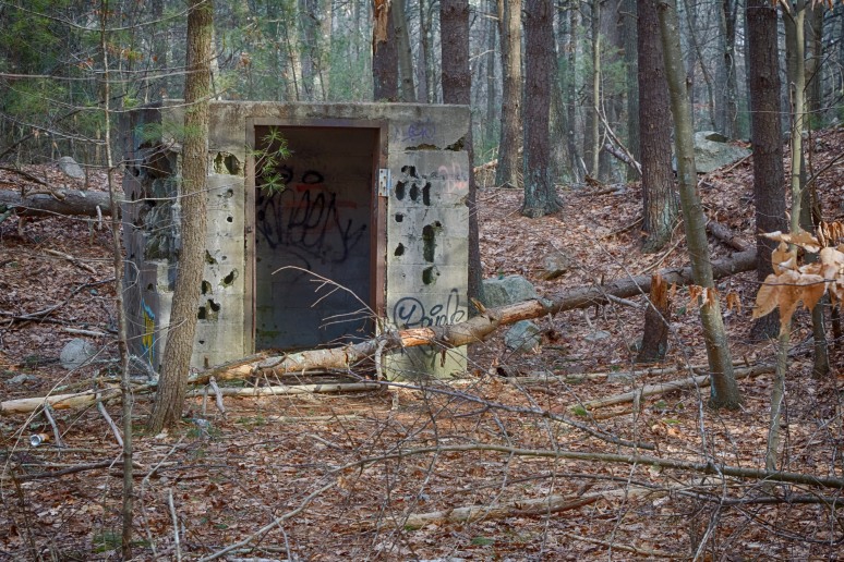
Back To The Woods
Well, that was a bit of a hiatus. Apparently I’m not only like a bear in shape, as I’ve been hibernating through the colder months. A combination of other things to do, a lack of inspiration for my photographs over the Fall, and the cold weather combined to still my shutter finger. With this weekend closer to early Spring than late Winter, I decided I needed to at least get out for a walk, even if it wouldn’t likely yield any interesting photos, and so I returned, once again, to Wompatuck State Park.
It was apparently a popular idea, as I passed a number of families and small groups out for a walk, as well as a few solo or paired cyclists.
I keep returning there because the extensive trails mean that there are still plenty of places I haven’t yet hiked even once. This time though, I was revisiting well-trod paths, more to get a sense for how the season had changed them than with any expectation of finding something new to inspire me.
Although this winter has been mild in comparison with last year, recent weeks have been hard on the trees. A heavy wet snow, followed by a quick freeze/thaw cycle, and then a windstorm delivered a 1-2 punch that brought down tress all over. This weekend’s warmth, with both days close to 60°F (15°C) likely made things worse, as frozen ground thawed and became even more saturated with water.
The park was no exception, with the boggy ground providing poor support when saturated, and many trees had fallen. While most of the downed trees were deadwood, several healthy live ones had fallen across the trails I hiked today. On the major trails most of these had been cut up or pulled to the side, but the secondary trails were still blocked in places.
Deadfalls are particularly dangerous just after a storm, as things can shift and suddenly fall. At one point, just after a bicyclist going the other way had passed me on one of the dirt trails, I heard a sharp “crack” from up ahead, and looked up from the trail just in time to see a tree that had been leaning across it come down. It was the end of the trunk that came across the trail, about six inches (15 cm) in diameter, and it only fell about ten feet (3 m), but had it fallen just a little sooner it might have hit the cyclist, or later, me, and done serious damage. The tree looked dead, and looking off to the side, I could see that the roots had pulled out of the ground when it first fell, and it had just been resting across branches of another tree.
The trigger may have been a small breeze, as I heard the treetops rustle about the time it fell. It was otherwise a mostly windless day. Whatever the cause, although I’m usually careful to keep an eye on overhanging trees, the remainder of my walk was done with more caution than usual.
I took a number of photos, though as usual they appeared less interesting when I looked them over later. But this hut, which I’ve photographed before but never found interesting, caught my eye today. Perhaps it was the sun, peeking through from the clouds, or the downed tree across the doorway, which I don’t recall from my last visit. I don’t know, but it just seemed more interesting this time out.
I’ve no idea what the structure was. As I’ve mentioned before, the park was formerly a Naval ammunition depot, and this was near to the trench-like structures, although located along a twisting road rather than one of the former rail lines. It may have been a shelter for guards, although it seems to be located too far from the road for that, and too small to be a storehouse. Perhaps it sheltered a phone; there was the cut-off base of a telephone pole nearby, although that could have been simply for electricity. Whatever it was, I doubt I’ll ever know.
The damage to the structure is part of what gives it character. It looks like some veteran of a war zone in the quiet woods, although since no conflict ever raged here, that’s almost certainly the work of bored hunters (or really, really, big woodpeckers). The way the color of the aged concrete matches that of the nearby stones is also interesting, making the structure seem strangely to fit the location, while its sharp lines make it look alien to the natural scene. A study in contrasts in many ways. The picture’s a little too “busy” with all the foreground clutter to be one of my better images, I think, but I like it anyway.
This image is, as are most of mine, an HDR made from a bracket of five exposures at 1 EV offsets. In this case the bracket was centered at 1/160th-second, with f/14 and ISO 3200. I didn’t intend to use f/14, but apparently the knob had got bumped at some point and I didn’t notice. A pity, as I could have used a lower ISO if I’d realized. The photos were taken without my usual polarizing filter, as the close trees made haze reduction a moot point. Processing was fairly simple: after finding that two of the presets produced similar good images, I started from one of them, Deep 2, dropping exposure and saturation slightly while boosting contrast. The result feels true to what I recall from the woods.
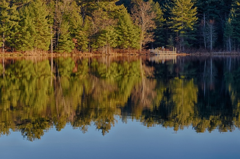
Lake Side
Well, that was a bit longer than usual between posts. It’s not for lack of trying, but I just haven’t turned up much that inspired me to take interesting photos (I have plenty of uninteresting ones…).
Today I wasn’t expecting much. I was back at the Assabet River National Wildlife Refuge, which is a much nicer place at this time of the year when the mosquitos are all gone than it is mid-summer. But it’s also mostly just trees, aside from the old bunkers, which honestly aren’t very photogenic. But I went down a trail I hadn’t traveled before to the edge of the small lake there, and caught the late afternoon sun just right.
The sky was a cloudless blue, although a bit hazy, and the air was almost completely still, which made the water a near-perfect mirror. I took this photo of a fishing pier, now abandoned for the season. The original had the horizon mid-photo, with the water mirroring the sky symmetrically. It had looked good at the time, but when I when to process the image it turned out to be really dull. Perfect symmetry isn’t very interesting. And the water was a much richer blue than the sky, probably an effect of my circular polarizing filter.
Whatever the reason, I decided to try cropping off the hazy sky and part of the left side, leaving me mainly with the blurred reflection of the trees. It’s not my best photo by any means, but it captures the feel of a quiet late-autumn Sunday afternoon in the woods, so I think it’s a success.
This image is, as usual, an HDR made from a bracket of five images. These were taken centered at 1/160th-second exposure, with ISO 1600 and f/11, with the lens at 99 mm. I used the circular polarizing filter, set to about half-intensity, and as noted cropped the image slightly. Processing was lightweight: I took the defaults except for a touch of saturation, a slight reduction of exposure (the left side was too bright) and a small reduction of the Highlights (to further tone down the brightness of the tree trunks mainly).
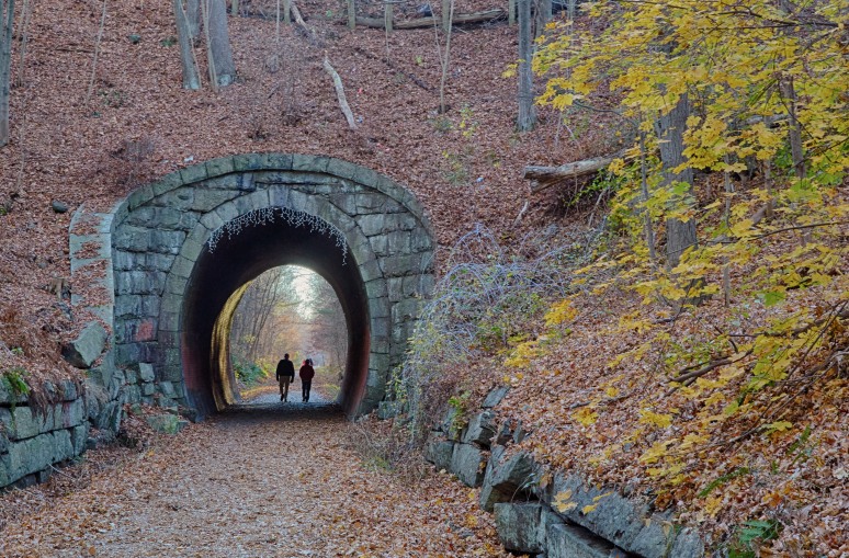
Phipps Tunnel
Fall is well advanced, but the weather has remained reasonably warm. It’s jacket weather now, but still quite comfortable. Photographs of interest haven’t been too common though; I’ve been revisiting familiar places on my weekend hikes, and inspiration has been wanting. This week though, I have something new and interesting.
This is Phipps Tunnel (also known as the Highland Street Tunnel), on the Upper Charles Trail, a bike/pedestrian trail network slowly being assembled by five towns. The tunnel is located in Holliston, Mass., on a section of railway that saw its last train sometime before 1987 when it was formally abandoned (the section beyond here to Milford was saw its last train in 1972 and the rails were lifted in 1974). This portion, south of the town center, has a hard-packed gravel pavement now, new in the last couple of years. It’s easily accessible too: there’s a parking lot in the center of town at one end, and another (less well marked) a few miles away on Cross St. (that one isn’t marked, but appears on a town map of a local woodland preserve).
The railroad was originally the Milford branch of the Boston and Worcester Railroad, built in 1848, although it changes hands and names a number of times after that. It was a small branch, and the first of several railroads to reach Milford, drawn by the potential of the granite quarries in the region. Milford was known for producing both “pink” and gray granite. This tunnel, like several other structures on the railroad, is made of granite from the railroad’s own quarry in Milford.
I read in one place that this was the “pink” granite that the region was famous for, but apparently that wasn’t discovered until 22 years after the tunnel was built, and it looks gray anyway so I’m guessing that this is ordinary gray granite.
Other sources have said that apparently it can vary from gray to pink and still be called “pink”, although this may simply be confusion over the fact that Milford produced more than one kind of granite. Regardless of which stone it used, the railroad branch actually picked up a nickname from the stone: the “Pink Granite Line”. If you’re interested in more about the railroad, there’s a PDF of interesting information, including an article on the history, linked off the Massachusetts Historical Commission page about the tunnel (the link isn’t obvious, you have to click on an icon).
The tunnel is an interesting structure, dating from the early years of railroading in America. The ovoid shape is something I’m more used to seeing in images from overseas; later American structures tended to be more a simple inverted “U” shape. The cup-shaped abutments are odd, too: I’ve never seen anything else shaped like that.
The tunnel is 70′ (21 m) long and 15′ (4.6 m) high. Small enough that the final locomotives to work the line fit through “with inches to spare” according to one report. It (and the hill through which it cuts) was named for Eli Phipps, the farmer who sold the land here to the railroad. The rail trail is probably the only thing that saved the tunnel. It was beginning to be eroded by water and ice, due to the poor drainage in the cutting (not very good even when the railroad was operating). It’s not on the National Register of Historic Places, but it is eligible and really ought to be: this is a rare piece of history.
I’m a bit confused as to the actual structure of the tunnel. The arch at each end is clearly a keystone arch, but it only extends one course into the tunnel. The rest of the lining is brick. And the facing stones, although made of the rough-cut rectangular blocks common to mid-century work, have mortar between them, which isn’t typical of other structures from that period. Perhaps that was a later repair, or perhaps it was required due to the mass of hill being held back. On the other side of the hill, a more modern concrete retaining wall holds back the hillside above the tunnel. The hill there is steeper, perhaps due to a later widening of the road. On this side, the hill is more gently angled, but still quite steep.
I like the photo for the fall scenery, with the fallen leaves, some plastic icicles hung above the tunnel mouth, and the splash of color from the leaves on the right. I was particularly fortunate to capture two people in silhouette as they exited the tunnel, which I think improves the image considerably. The splash of late-afternoon sun illuminating the inside of the tunnel, revealing the brickwork, is a nice feature. It’s not all good: if you look close, my focus was off enough that even sharpening doesn’t help much. In smaller sizes it’s not noticeable, but at full size it’s quite obvious. The light was rather dim and autofocus wasn’t working so I switched to manual, then I moved and forgot to re-focus.
The image is, as usual, an HDR from a bracket of five exposures. The bracket was centered at 1/100th-second exposure, with ISO 1600 and f/11, with the lens at 60 mm. Processing was limited to a boost to exposure, contrast and saturation, a slight shift to the yellow (the cool diffuse light on this side of the hill became an icy blue in the HDR processing) and a slight adjustment of tilt. Although I also had to do much more than the usual level of ghost removal and retry several times with different choices of key frame, due to the walking people (the one on the left kept coming out with three legs, or no head). The final image was cropped to better frame the tunnel, and sharpening was performed, although without much effect.
Whistler’s Bridge

I missed another week. I suppose at this point I should just admit that I’m not finding enough time/inspiration and switch to an every-other-Friday planned schedule. I’d still like to post something new each week, I just seem to have trouble doing it this year.
But today I have something good. This week was vacation, and I managed to hike the Keystone Arch Bridges Trail, in Chester, Mass. This short (about 2.5 miles, 4 km) trail has four stone arch bridges, plus the abutments of a fifth destroyed in a 1927 flood, and one of them, shown above, is still in use after 174 years by the successor of the railroad that built it. Today’s post will have a bit of history of railroading, and some information about another nineteenth-century engineer, two actually.
Let’s start with the engineer: George Washington Whistler, father of the famous painter and thus, obviously, the husband of the subject of the well-known painting, Whistler’s Mother (his second wife, Anna McNeill). Unlike many engineers of the time, who learned their craft as assistant to some other engineer, George, born in 1800, attended West Point, where he studied engineering and graduated in 1819, eventually attaining the rank of Major. He served in the Army Corps of Engineers and the Topographical Survey (this was before the Army created a Corps of Topographical Engineers).
It was peacetime and the Army wasn’t doing a lot of construction, so they loaned Whistler and another officer, William Gibbs McNeill, to the Baltimore and Ohio Railroad (the B&O) to survey a route west to the Ohio river. The B&O was the first American railroad, and likely a very interesting place for an engineer to work in those early days. The officers had known each other as cadets, and Whistler eventually married McNeill’s sister. This was the start of a collaboration that spanned the transition from canal-building to the early U.S. railroads. McNeill would go on to do quite a lot more, but he’s not today’s main subject since he wasn’t involved in this bridge.
While working for the B&O in 1828 Whistler was sent to England to study railroad and locomotive design. He brought back information that was used to build the first locally-manufactured steam engines. The Smithsonian also credits him with introducing the steam whistle to American locomotives.
Whistler eventually left the Army, and a short time later (1833) went to work on the Middlesex canal connecting Lowell to Boston. Sometime around then he also worked on the Boston & Lowell Railroad as well as on the Boston & Providence Railroad with McNeill. For the latter, McNeill was apparently the senior member of the team, and thus gets credit for the Canton Viaduct, although Whistler and two other officers assisted.
The Proprietors of the Lowell Canal System had a fairly extensive engineering staff, complete with their own shops for making turbines (and later steam boilers) and they constructed some of the early railroad locomotives for Boston’s new railroads, which were apparently copies of the British Planet locomotive, although engravings show some differences in form. Whistler was the superintendent of that shop from 1834 to 1837. In 1837 Whistler left Lowell to focus on railroad construction.
One of the early railroads of Boston was the Boston & Worcester, which was built between 1832 and 1835. It doesn’t appear that Whistler worked on this one, but if so it was the only one of the set that he missed. By 1836, work was underway to extend the railroad from Worcester to the New York state line as a separate railroad, the Western Railroad. Springfield, on the Connecticut River in western Massachusetts, was reached in 1839, and the complete route to the state line, where it connected with another railroad, was put into service in 1841. The goal was to give New England’s industries an outlet to the growing markets in what is now the central U.S.; back then that was the frontier. In reality, while it did that, it also opened New England to new industries operating in the west, which was probably more significant in the long run.
Now interestingly, one of the abutments of one of the out-of-use bridges bears a stone with the date 1844 carved on it, and I’ve read elsewhere that the bridges weren’t completed until then, although no source was cited. It would seem that they were using temporary trestles when the line opened, and hadn’t finished the bridges at that point. It wasn’t unusual to have a trestle across an in-construction bridge, as those were used to fill the structure with rubble; only the outer faces would be smooth stone. Or perhaps the temporary structures were off to one side, although room to do that was very limited.
Whistler, initially while still working at Lowell, was also “construction engineer” for the Western Railroad, and apparently worked with McNeill on the portion from Worcester to Springfield. McNeill left to work for another railroad at a salary “double…that which had been given to him…by us” per a Western Railroad report (1843, PDF). Whistler is credited as designer of one of the bridges on this section, a more modest structure than the ones I saw. And he’d credited with being the first to use a keystone arch bridge for a railroad. In 1840 he became chief engineer for the final stretch from Springfield across the Berkshires to the state line.
This was the hard part, particularly the long grade up from the Connecticut river. At Springfield the railroad is at 57′ above sea level (17 m). By Chester, 28 miles (45 km) as the track winds it has climbed to 600′ (183 m). In the next 12.6 miles (20.2 km) it climbs to 1,459′ (445 m) before reaching the summit at Washington (named for the president, not the engineer). The route is a hard one, with a portion built high up the sides of a narrow river gorge. One of the bridges rises 67′ (20 m) above the river. This grade has long been a problem for heavy freights.
The necessary grade isn’t really steep by modern standards, at 1.67% (I’ve also seen 1.65% noted). The B&O had one grade of 2.2%, and that went on to become something of a maximum specification for later mainline railroads (per Trains magazine, Sep 2011 issue). But up to then, railroads had mostly followed relatively level paths. And to make matters worse, it was (and is) a very curvy route, and curves make for more friction, requiring more power to pull the train. Apparently some of the early plans involved using horses, but Whistler managed to do it with steam locomotives the whole distance. Getting over the Berkshires by steam in 1841 was an amazing achievement.
Whistler seems to have been something of a perfectionist. When other railroads built cheap to start, and then upgraded when the money came in, often relocating whole lines in the process, he surveyed a route that’s survived largely unchanged down to the present. And where other railroads started with wooden trestles, he built massive stone bridges wide enough for two tracks to begin with (he did compromise to the extent of only laying one track).
That may not be perfectionism so much as practicality though. These bridges were in a remote location subject to heavy spring floods. A washout would be difficult to repair, not to mention expensive. Stone would also be less likely to catch fire. Early wooden bridges often had tenders assigned to them, men who could put out fires sparked by burning embers from the locomotives. That probably wasn’t practical here. And as for the route: it follows a river, and without major engineering, it’s not going to get any straighter. There actually was some of that: the other bridges are unused today because of a straightening project performed in 1911 that reduced the number of river crossings and made the curves wider on this section.
But back to Whistler’s achievements: In the 1830’s, the typical locomotive was a derivative of Stephenson’s Planet that weighed 12 tons (11 metric tonnes). For his steep grade, Whistler commissioned several 19.5 ton locomotives (18 tonnes) base weight, or 22.8 tons (20.7 tonnes) loaded with fuel and water. These were (per this book and the report cited below) Ross Winans’ Crab design with eight small connected driving wheels, a gear drive and a vertical boiler. The first, named Maryland, was purchased in 1841 after it had been in trials with the B&O. Although the number has been given as three in some sources, there actually appear to have been seven of them purchased as a single order.
The gear-driven eight-connected locomotive appears not to have been a very successful design, nor were the ugly devices well-liked by the railroad. One director of the corporation referred to their purchase as “rash investments in engines of new patterns”, and this may have been what led Whistler to leave the Western Railroad in 1842. Little documentation has survived about them. In any case, they were more than able to haul trains up the grade, even if they were later replaced by other designs that were more successful. Several tests carried out after Whistler left proved that they could out-haul other contemporary locomotives, and use less fuel doing it. Whistler’s choice was a success.
Given the paucity of information on these locomotives, it’s worth saying a bit more about them. The 1843 report noted above is an account of a stockholder-initiated investigation into several matters of financial concern as the new Western Railroad moved from construction to operation and began to worry more about being competitive and generating a dividend. Among these was the choice of locomotive. In 1838 a committee led by McNeill had recommended the purchase of “six ten-ton and two fourteen-ton” locomotives, with Whistler to be responsible (as “chief engineer”, so maybe he held that position before 1840) to “make the drawings and superintend the work”. For the Berkshire portion of the line, Whistler selected three Lowell engines of the existing design (likely Planet-derived designs) for passenger use, seven from Winans for “merchandise” (based on the Crab design) and two small Gillingham & Winans locomotives (which were used over a connecting line owned by another railroad that was built too light to support the Western’s usual locomotives). It’s also worth noting that the term “Crab” was a derisive nickname applied by those who didn’t like the engines; they were otherwise known as “the Winans”. But the name stuck, and was applied to later designs of similar locomotives as well.
The Winans merchandise locomotives were selected after Whistler was dispatched to Baltimore by a selection committee to investigate claims of a new and powerful engine design, which was in use on the B&O. After positive comments from that railroad, Whistler viewed a trial and after he returned to Massachusetts the committee dispatched two members to view additional trails and contract for seven locomotives if they proved suitable. They were, and the purchase was made despite the locomotives costing more than 20% above competing designs, and 50% above what one competitor apparently offered. While it appears that a selection committee made the choice, not Whistler, as chief engineer it was clearly his responsibility to approve the choice. And the selection of a new and untried technology seems to fit the character of a man who was the first to use a stone arch bridge for a train, and whose constructions reflected an emphasis on technical suitability over cost. I think it’s fair to say that he chose them.
As for the locomotives, all seven were delivered and put to use, though not without problems. At least three of the seven were built under contract to Winans by Baldwin and Vale, which is probably the origin of the confusion over the number purchased. The Maryland was delivered in January of 1842, followed by the Michigan, Ohio, Illinois, Arkansas, Indiana and Missouri through the rest of the year. The high cost of purchase, and the decision of the B&O not to purchase any after their own trials, plus some initial mechanical issues, created something of a controversy for the railroad. This was fanned by an unhappy loser, William Norris.
Norris was, however, in some kind of financial trouble and probably needed the sale badly, and he was found to have exaggerated the results of some B&O testing, so his comments are hard to take at face value. His more conventional locomotives, likely his 2-2-0 design, if built, might have met the railroad’s needs at a lower cost. Or not. He had previously demonstrated that the design could pull loads up a grade, but they were never tested on the actual Berkshire route.
In the Winans locomotives’ first year of service, traffic was even higher than projected, and the engines were often overloaded pulling trains beyond their design specifications. This led to mechanical failures (in some cases due to undersized mechanical parts that were then redesigned). Inexperienced crews also damaged the boilers of a couple of them. Despite this, the committee reviewing the financials found that they cost less to run, per mile, than the Lowell engines had in their first year, and that the overall freight operations had been more profitable than those of competing railroads, despite the severe grades. This was probably helped by the fact that it turned out that more freight was coming from Albany than going to it (i.e., more was going down the steep hill than up it), but still the much-disliked Crabs appear to have been a success.
Maybe they weren’t the best possible choice at the time, maybe they were. Even hindsight can’t answer that question. Longer-term the design had limitations, particularly in terms of low speed (top speed was just 12 mph, 19 km/h; acceptable in 1841 but not for long). Winans had problems with his later models not working as promised. In any case, the industry turned away from them and to the precursors of what we now think of as steam locomotives: a smaller number of large driving wheels, with separate wheels to help spread the weight of a larger boiler and firebox. In short, the design Norris had proposed.
In later years gear-driven locomotives would only be used on very steep railroads, mostly logging lines rather than general freight mainlines. Later locomotives purchased by the Western Railroad appear to have been more conventional, although the steep grade still required specialized locomotives. An entire class of steam locomotive, the Berkshire, was designed (c. 1925) to deal with the problem steep mountain railroad grades posed, and gained its class name from adoption for use on this route.
Today, Whistler’s remaining in-use bridge still carries two tracks, and over it run trains he couldn’t even begin to imagine. A typical modern freight will be pulled by two 4,000 hp (3 kw) locomotives weighing in at 196 tons (178 tonnes) each, and they have to work at it. The sound of a set pulling a freight train uphill is quite impressive. It may not be as well-known as the Canton Viaduct, and it doesn’t carry high-speed rail, but a substantial portion of the freight to and from southern New England still passes over Whistler’s bridge, as it has for 174 years (or 171 years, take your pick). That’s quite a legacy.
Whistler wasn’t done making his mark on railroading either. In 1842 he went to Russia to help design the Moscow to Saint Petersburg Railway (Winans was involved in this, too, and sold the railroad a number of his Crabs). There he apparently selected the five-foot gauge for the track (it was popular in the U.S. at the time). That gauge is still used by Russian and former Soviet-bloc railways today. He completed that project, and did several other engineering works in Russia before dying of a heart attack in 1849 after being weakened during a cholera epidemic. He never returned to work on more American railroads. McNeill did, and had a long career. Without a doubt he’s a more significant engineer in the history of this country. But Whistler and his achievements should not be overlooked in the shadow of his friend.
Back to the bridge: the stone arch bridge is an ancient design. The Romans used them widely, as well as using true arches (arches with keystones) in other structures. They are amazingly solid and stable, and added weight only makes them stronger. Many of those Roman bridges remain in use today. So it’s not really surprising that Whistler’s bridges are still with us. And yet, locomotives today weigh ten times (or more) what those heavy Crab locomotives weighed. Freight cars are similarly heavier. At a conservative guess, more than half a million trains have crossed the bridge at the top of this post since it was constructed. Whistler built for the ages. And that, I think, is something any engineer would want to be remembered for.
As a photo, I like this image because it’s a beautiful stone structure in a lovely location. Fall isn’t fully advanced yet, but the yellowing leaves work well with the late afternoon sun. Photographing it back-lit wasn’t ideal, but the only way to get to the downstream side without trespassing involves wading under the bridge, and I didn’t feel like making the long drive home sopping wet. And the strong afternoon light passing under the bridge actually gives this image some character it wouldn’t have if shot from the bright side. I did have a problem with some lens flare on the far right, but cropping out the trees on that side (along with some foreground rocks) eliminated almost all of that.
This image is, as usual, an HDR made from five exposures. The bracket was centered at 1/200th-second exposure, at ISO 400, f/11, with the lens fairly wide at 32 mm. I actually took a number of brackets at different settings trying to find one that kept the sky from blowing out while still preserving dark details due to the high contrast (I probably should have used 2 EV steps rather than 1 EV for my bracket). I did not use the circular polarizing filter (it was too dark, and shooting into the sun isn’t likely to yield much benefit from one anyway). As noted I cropped it to fit. Adjustments were fairly minor. I had to back off exposure a bit, and applied a neutral-density filter to the top portion. Back in C1 I applied the usual sharpening before export.
Early Fall Bike Path

I missed another week. My weekends have been busy of late, and I haven’t been getting out as much as I’d like, which leaves me short of interesting photographs, as well as exercise. This weekend I managed the latter, although I was covering familiar ground, so there was less inspiration than I’d have liked.
I was back at Wompatuck State Park, hiking some of the rough woodland trails I hadn’t been on before. Most of these are primarily for mountain bikers, although they make good hiking if you don’t mind stepping aside periodically for the bikes (the trails are barely wide enough to walk single file). Those trails go through the woods, mostly away from the relics of the land’s former use as a military base, so aside from interesting rocks and trees, there’s not much photogenic. It was a good hike though, and the only bikes I saw were families out on the paved trails.
I took this image back on one of the main bike paths, this one the recently created trail up to the Cohasset commuter rail station. Until last year, this area was the last portion fenced off and littered with crumbling buildings left over from the tail end of the Cold War, when it had been a facility for testing missile engines, among other things. Last year, they bulldozed the last of those into earth-covered heaps like this one (except for a few too solid to knock down), removed razor wire and other hazards, and paved a few of the trails, before adding it to the rest of the park’s network.
What I like about this image is the way it captures the look of late summer / early fall (technically the latter now). The days are still comfortably warm, but the nights are getting cooler. The long grass has started to yellow, although in part that’s due to the relatively dry summer we had. The trees aren’t quite changing color yet, but you can see a few yellowed branches, which probably have more to do with the dry weather than the cold at this point.
Plus it’s a good photo of a nice bike path through mostly natural scenery. Aside from the oddly regular mound aside the trail, the only visible relic of the past is the tall pole at the left, one of many. I believe it’s a lightning rod, as these were placed to bracket the structures.
This image is, as usual, an HDR made from a bracket of five photographs. The bracket was centered at 1/25th-second exposure, with ISO 400 and f/11, with the lens at 47mm. I did not use the polarizing filter, as the sky was a haze-free blue all on its own, and the light was getting a bit dim under the trees, although it was still quite bright out where I took this one. Adjustments were minor, I didn’t use any preset, merely boosting contrast and lightening the blacks to bring out detail under the trees. The yellow of the late-afternoon sun comes through clearly all on its own, helped by the yellowing vegetation. I did apply sharpening before the final export.
Images licensed as:

